Santiurde de Toranzo
Appearance
Santiurde de Toranzo | |
|---|---|
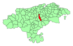
 Location of the Municipality of Santiurde de Toranzo | |
| Coordinates: 43°14′23″N 3°56′16″W / 43.23972°N 3.93778°W | |
| Country | |
| Autonomous community | |
| Province | Cantabria |
| Comarca | Valles Pasiegos |
| Judicial district | Medio Cudeyo |
| Capital | Santiurde de Toranzo |
| Government | |
| • Alcalde | Aniceto Pellón Rodríguez (2007) (PP) |
| Area | |
| • Total | 36.82 km2 (14.22 sq mi) |
| Elevation | 120 m (390 ft) |
| Highest elevation | 876 m (2,874 ft) |
| Lowest elevation | 73 m (240 ft) |
| Population (2018)[1] | |
| • Total | 1,623 |
| • Density | 44/km2 (110/sq mi) |
| Time zone | UTC+1 (CET) |
| • Summer (DST) | UTC+2 (CEST) |
| Official language(s) | Spanish |
| Website | Official website |
Santiurde de Toranzo is a municipality of Cantabria. The Pas River runs through it.
Towns within the municipality
[edit]- Acereda
- Bárcena
- Iruz
- Pando
- Penilla
- San Martín
- Santiurde de Toranzo (Capital)
- Vejorís
- Villasevil
References
[edit]- ^ Municipal Register of Spain 2018. National Statistics Institute.
External links
[edit]- (in Spanish) Ayunt. de Santiurde Toranzo


